 Lauterbrunnen City Guide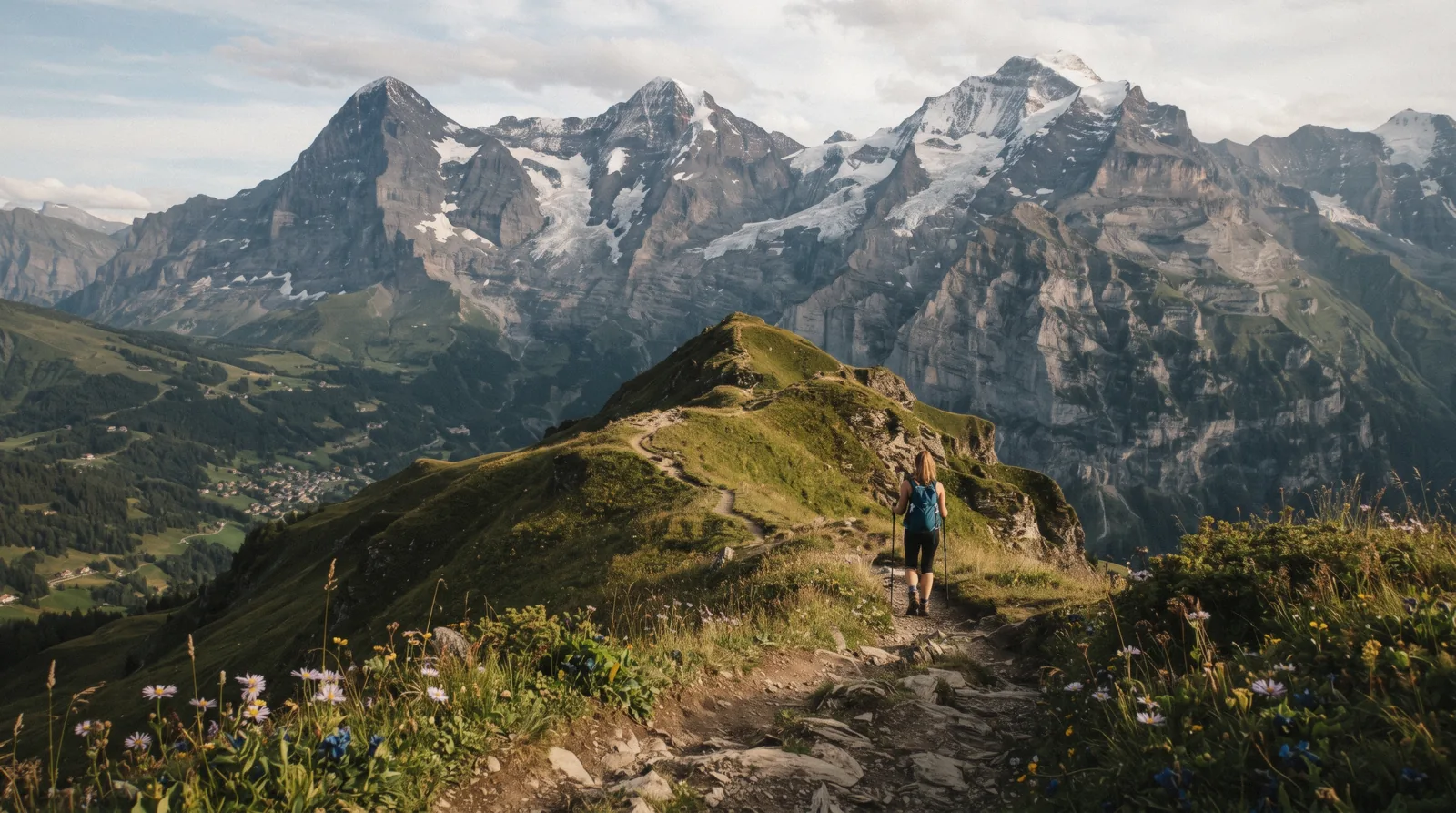
North Face Trail, Mürren
This page is about the North Face Trail Mürren hikers search for, in the Bernese Oberland, the one named by Mürren Tourism's own hiking page. It is not about any other trail of the same name elsewhere in the world, and those exist. We will be direct about what we can prove and what we cannot. The trail exists, carries that name on the official tourism site, and runs in the immediate vicinity of Mürren, a car-free village at 1,638 m on the side of the Lauterbrunnen valley that faces the Eiger, Mönch and Jungfrau massif. What no official page publishes is the trail's length, its walking time, its elevation profile, its difficulty grade or a trailhead coordinate. That gap is real and we will not paper over it with invented numbers. What you get here instead is the confirmed picture, the other named trails at Mürren for comparison, the cableway fares you need to reach the village, and a practical plan for getting the current route details on the ground. For the wider Lauterbrunnen valley, start with our things to do overview.
Quick answer The essentials on the North Face Trail at Mürren
The North Face Trail is one of the named hikes on Mürren Tourism's official hiking page, which calls it "the ever-changing Northface Trail". It runs in the immediate vicinity of Mürren, a car-free village at 1,638 m on the valley side facing the Eiger, Mönch and Jungfrau, the peaks whose north faces give the trail its name. It is free to walk with no booking needed. What is not published anywhere official: the length, the walking duration, the difficulty grade, the elevation profile and a trailhead coordinate. The trail appears on Mürren Tourism's interactive trail map rather than a text page, so check that map or ask in the village before you set out.
Key takeaways
- Named by the official Mürren Tourism hiking page, described only as "the ever-changing Northface Trail"
- Free, no ticket, no booking, reached by cableway from Stechelberg or the Grütschalp route, both covered on Mürren
- Length, duration and difficulty are not stated on any official page, so verify locally
- Plan the rest of your stay on the main Lauterbrunnen Switzerland guide
Key facts
Opening hours
| Trail access | Open–Daylight hours, year-round conditions permitting |
|---|
Closed Not stated. Snow cover likely closes or changes the route in winter, not confirmed by an official source
Planning it
- Time needed
- Not stated by any official source. Our estimate: allow at least an hour based on comparable Mürren trails, verify locally before you go
- Address
- Near Mürren, 3825 Lauterbrunnen, Switzerland
The North Face Trail itself costs nothing and needs no reservation. The costs below are transport fares to reach Mürren, the village the trail starts from. Cableway and tour figures come from the operators and the tour listing, not from any trail source.
The trail has no entry fee, so the only money involved is getting to Mürren. Here are the ways.
| Option | Price | Covers | Book ahead | Book |
|---|---|---|---|---|
| Stechelberg-Mürren cableway returnMost walkers, especially drivers, who park at the Stechelberg cableway bottom station | US$28.70 (CHF 23.60) | Reaches Mürren, the trail's base village. Single is US$14.34 (CHF 11.80). Free with GA, Swiss Travel Pass or Berner Oberland Pass | Not needed, buy at the station | Official site |
| Grütschalp route from LauterbrunnenAnyone arriving by train at Lauterbrunnen who prefers the rail side of the valley | Fare not stated in this run's sources | Cableway to Grütschalp then the mountain railway to Mürren, about 20 minutes in total | Not needed | Official site |
| Lauterbrunnen-Mürren: Swiss Alps Tour from InterlakenVisitors without a car who want transport and logistics handled, and are happy to self-guide the walking portion | $310.00 | A 7-hour rail and cable car day from Interlaken with three free hours in Mürren. It does not include or guide the trail walk, but that free time could be used to walk part of it on your own | Yes, 24 hours before the start time | Check Availability |
Figures current in Q3 2026.
Getting To Mürren First
No bookable tour on this site is built around the North Face Trail, and we will not pretend otherwise. The only general-area product is this Mürren day trip from Interlaken. Its guided parts cover the journey and the village, not the trail. Its three hours of free time in Mürren are the portion a walker could put to use on the path. If you want a dedicated guided hike here, none is listed by our sources.
 from $310.00
Lauterbrunnen-Mürren: Swiss Alps Tour from Interlaken
An hour in Lauterbrunnen village then three hours loose in car-free Mürren, all by public rail and cable car with a small group. Trümmelbach Falls sits on the route but its entry fee is paid separately at the gate if you stop there.
Check AvailabilityPrices, ratings and details are the platform's own. Dollar figures are the listed prices. The platform bills in your account's currency.
What Is Actually Confirmed
Here is the complete list of what official sources establish about this trail, and it is short. Mürren Tourism's own hiking page, on muerren.swiss, lists the "Northface Trail" among the village's hikes, alongside the Rotstockhütte via Wasenegg loop and the Detective Trail. The site describes it with a single phrase, "the ever-changing Northface Trail". One image on that same page carries the caption "Northface Trail Mountain View Trail", which suggests an alternate or informal name. That is the whole of the official text.
Beyond the wording, the context is solid. The trail is in the immediate vicinity of Mürren, a village at 1,638 m on the east side of the Lauterbrunnen valley, which is the side facing the Eiger, Mönch and Jungfrau massif. Those are the peaks whose north faces are visible from Mürren's viewing terrace and from which the trail takes its name. Mürren is car-free and reached only by the Stechelberg-Gimmelwald-Mürren cableway or the Grütschalp cableway and train.
Now the gaps, stated plainly. No official page reachable in this research publishes the trail's length, its walking duration or its difficulty grade. There is no standalone description page. The trail exists as a layer on Mürren Tourism's interactive trail map, a JavaScript map rather than a text document, so its details cannot be quoted here. A dedicated village site that might once have carried such a page, mymuerren.ch, now redirects to an unrelated online-casino site and is not used anywhere on this guide. We would rather leave these blanks visible than fill them with guesses.
Source: muerren.swiss hiking page.
One Trail, Two Names, And A Naming Collision
Two naming points matter before you search for this trail anywhere. First, Mürren Tourism spells it "Northface Trail" as one word in its listing, while walkers commonly write "North Face Trail" as two. Its own image caption adds a second label, "Mountain View Trail", so the same path may appear under either name on signposts, in guidebooks or on the interactive map. If a sign in Mürren says Mountain View Trail, that is plausibly the same route, though only local signage can confirm it.
Second, "North Face Trail" is a heavily reused name. Trails of that exact name exist in the United States, for example in Pennsylvania and in Glacier National Park, and the phrase also collides with the outdoor clothing brand. Search engines mix all of these freely. So if you arrive at this page from a generic search, check that you meant the Mürren one, the path above the Lauterbrunnen valley in Switzerland with the Eiger, Mönch and Jungfrau north faces across the valley. Questions about the American trails are outside what this page covers, and we will not answer them here.
Source: muerren.swiss hiking page, including the image caption.
The Other Named Trails At Mürren
Mürren Tourism's hiking page names three options in total. The other two are documented in more detail than the North Face Trail, which is useful both for comparison and as alternatives if the route is unclear on the ground. Their published facts are below.
Comparing the official Mürren hikes
The Rotstockhütte via Wasenegg loop is the serious half-day option. The Detective Trail is the family option. The North Face Trail sits between them in reputation but not in documentation, which is exactly the gap this page keeps flagging.
| Trail | Duration | Notes |
|---|---|---|
| Rotstockhütte via Wasenegg loop | 4h30 | Starts at Spielbodenalp, reaches the Bryndli viewpoint by a short detour, then the Rotstockhütte mountain hut |
| Northface Trail | Not stated | Described by the tourism office only as "the ever-changing Northface Trail". Also captioned Mountain View Trail in one image |
| Detective Trail | Not stated | A flat, easy puzzle trail for children. Answers come via an app or printed sheets from Grütschalp station or the Alpine Sports Centre in Mürren |
Source: muerren.swiss.
How To Plan A Walk Here Anyway
Gaps in the official record do not make the trail unwalkable. They just move the planning onto the ground. Here is a workable sequence.
Before you travel, open Mürren Tourism's interactive trail map on muerren.swiss. The Northface Trail lives on that map layer, so it may show the routing, and the map is the closest thing to an official description that exists. Pair it with our own Lauterbrunnen map for the wider valley.
On arrival in Mürren, ask. The village has an Alpine Sports Centre, which is also where Detective Trail answer sheets are handed out, and the local tourist information can print or point you to the current trail map. Signposting in the Jungfrau Region is generally good, and if the path is signed as Mountain View Trail, ask which name applies to the route you want.
Give yourself margin. Because no duration is published, start early, carry water and a layer, and turn back on schedule rather than pushing on. Mürren sits at 1,638 m and paths here run on alpine terrain, so standard precautions apply. Check the weather forecast in the morning, since cloud can close over the very views the trail exists for. Snow likely alters or blocks the route in winter, though no official source confirms the seasonal closure pattern. For more walking ideas across the valley, see our Lauterbrunnen hikes section, and for a different kind of clifftop outing nearby, the Mürren via ferrata is documented in detail.
Source: muerren.swiss hiking page and arrival page.
Mürren And Its Trail Network
The pin marks Mürren village, not a trailhead, because no trailhead coordinate for this trail is published anywhere official.
Coordinates approximate. This trail has no published trailhead GPS, so the pin marks Mürren village.
Other Ways To See The View
If the trail's exact routing stays unclear or the weather turns, these Mürren-area options put you in front of the same Eiger, Mönch and Jungfrau panorama with far better documentation.
Allmendhubel
Mürren's local mountain at 1,907 m, a 4-minute funicular ride from the village. At the top there is a panoramic restaurant facing the Eiger, Mönch and Jungfrau, a Flower Trail past more than 150 mountain flower species, and playgrounds for children. Return fare from Mürren is US$19.44 (CHF 16.00). See Allmendhubel.
Schilthorn and Piz Gloria
The summit above Mürren with the revolving restaurant used as a James Bond film location. Continued by cableway from Mürren, adult return US$111.10 (CHF 91.40). Full details on Schilthorn.
Mürren via ferrata
A roped descent from the Mürren viewing terrace toward Gimmelwald, about 2.2 km with roughly 300 m of altitude change over about 3 hours, open 1 June to the end of October. Unusual because most via ferratas climb. More on Mürren via ferrata.
North Face Trail, Mürren Questions
How long is the North Face Trail at Mürren?
Not stated. No official page publishes the trail's length, and we will not guess a number. The trail appears on Mürren Tourism's interactive trail map, which may show the routing. Check the map or ask in the village for current details.
How long does it take to walk the north face trail murren route?
No official source gives a duration. Based on comparable Mürren walks we suggest allowing at least an hour as a rough floor, but treat that as our estimate only, not a published figure, and verify on the ground.
Is the Mürren North Face Trail hard?
The difficulty grade is not stated on any official page. Mürren Tourism calls it only "the ever-changing Northface Trail", which suggests varied terrain but proves nothing about difficulty. Ask at the Alpine Sports Centre or the tourist office in the village before committing.
Where does the North Face Trail start?
A trailhead coordinate is not published. What is confirmed is that the trail is in the immediate vicinity of Mürren, the car-free village at 1,638 m reached by cableway from Stechelberg or by the Grütschalp cableway and train. Our map pin marks the village itself, not a trailhead.
Is this the same North Face Trail as the one in Pennsylvania or Glacier National Park?
No. This page covers only the Northface Trail at Mürren in Switzerland, named on the official Mürren Tourism hiking page. Trails of the same name in the United States are unrelated and out of scope here.
Is there a guided tour of the trail?
No tour product on this site is built around the North Face Trail. The closest option is Lauterbrunnen-Mürren: Swiss Alps Tour from Interlaken, a 7-hour day trip at $310.00 that includes three free hours in Mürren, time you could use to walk part of the trail on your own. The tour itself does not include or guide the walk.
The Trail On Film
Three videos filmed on the Mürren Northface Trail itself, by the titles their own creators gave them.
North Face Trail in Mürren Switzerland: Incredible Views
A walk along the trail with views across to the Eiger, Mönch and Jungfrau.
Video: Girl DadNorthface Trail: A Journey of Adventure in Mürren, Switzerland
Footage of the route and its changing terrain.
Video: Travel Adventures: Vance and KimNorthface Trail Mürren, Switzerland 4K
A 4K walkthrough of the path above the village.
Video: Todd StevensWe may earn a commission if you book through one of our links, at no extra cost to you. Full affiliate disclosure