 Lauterbrunnen City Guide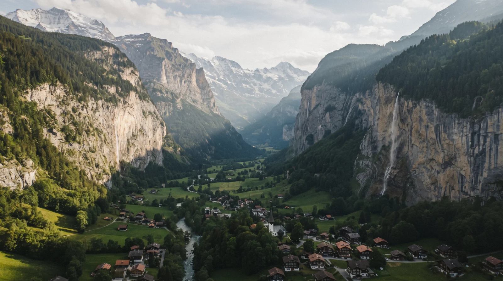
Lauterbrunnen Map: Valley Floor, Ledges and the Two Summits
This Lauterbrunnen map plots the municipality's geography in six colours: the free valley floor, the car-free ledge villages, the trails and via ferrata, the summits reached only by lift, the stations and lifts that link them, and the places to sleep, eat and shop. The summits sit well above the frame in reality, so this map plots them at their true ground position but the page text carries the altitude gap the pin cannot show. For the full list behind each pin, see things to do or the Lauterbrunnen homepage; for the tickets, tickets and passes.
Quick answer How the valley's geography actually breaks down
This Lauterbrunnen map has 45 pins in six colours: blue for the valley floor, green for the car-free ledge villages, orange for the trails and via ferrata, purple for the summits reached only by lift, teal for the stations and lifts, and berry for places to sleep, eat and shop. The floor and the ledges sit within a short cableway or rack-train ride of each other, and the summits are a further half-day to a full day beyond that.
Key takeaways
- The purple summit pins need a ticket: the Schilthorn at US$139.70 (CHF 115) return and the Jungfraujoch from US$157.50 (CHF 129.60).
- The blue and green pins are free to reach on foot once you have paid the lift fare up, except Staubbach Falls, which needs no ticket at all.
- The orange via ferrata pin only runs 1 June to 31 October; see the shortlist for the four pins worth a first visit.
The Map
45 pins plotted from the Swiss public-transport timetable's station coordinates and OpenStreetMap, in six colours. Blue is the valley floor, green the car-free ledge villages, orange the trails, purple the summits, teal the stations and lifts, berry the beds, supermarkets and the few restaurants this site can name from a source. Tap or hover a pin for its name, and use the numbered list below the map to find any pin by its number.
Valley Floor (Free) 6 pins
- Lauterbrunnen train stationFree to visitThe hub for every line in the valley: the Postbus, the rack railway to Wengen and the Grütschalp cableway toward Mürren.
- Staubbach FallsFreeA 297 m drop over the village, visible from the street, the subject of Goethe's 1779 poem about the falls.
- Trümmelbach FallsUS$21.90 (CHF 18)Ten glacier waterfalls inside the mountain, open early April to early November only.
- StechelbergFree to visitThe end of the valley road and the Postbus route, and the valley station for the Schilthorn cableway.
- Parkhaus LauterbrunnenUS$21.90 (CHF 18) per 8 hours974 spaces at the station, open around the clock, the car park for car-free Wengen and Mürren.
- Tourist office, Stutzli 460FreeThe valley's own tourist office, about 50 m from the station, open Wednesday to Sunday.
Car-Free Ledge Villages 4 pins
- MürrenUS$14.34 (CHF 11.80) cablewayCar-free at 1,638 m, the trailhead for the North Face Trail and the mid-station for the Schilthorn cableway.
- GimmelwaldBy cablewayOne cableway stop below Mürren, 1,364 m, home to the Mountain Hostel and the via ferrata's lower end.
- WengenBy rack trainCar-free at 1,274 m, reached only by the Wengernalpbahn, host village of the Lauberhorn races each January.
- IsenfluhBy PostbusThe quietest of the six municipality villages, on the slope opposite Wengen and Mürren.
Trails and Via Ferrata 8 pins
- North Face TrailFree to walkA high path above Mürren facing the Eiger, Mönch and Jungfrau walls directly.
- Mürren-Gimmelwald via ferrataFree (gear rental extra)About 2.2 km with a 90 m suspension bridge over the Mürrenbach gorge, open 1 June to 31 October only.
- AllmendhubelUS$19.44 (CHF 16) returnA funicular from Mürren into flower-meadow walking country, closed 19 October to 11 December 2026.
- Mürrenbach FallSeen from the via ferrataThe fall below Mürren that the via ferrata crosses on its 90 m suspension bridge.
- ObersteinbergOn foot onlyThe mountain inn at 1,778 m at the head of the valley, about 2 to 2.5 hours on foot from Stechelberg. Tolkien signed its guest book in 1911.
- OberhornseeOn foot onlyThe small lake above Obersteinberg inside the Jungfrau-Aletsch World Heritage Site, the far end of the valley's walking country.
- SpielbodenalpTrailheadStart of the Rotstockhütte loop via Wasenegg, about 4 h 30 m on foot.
- RotstockhütteMountain hutThe mountain hut on the loop from Spielbodenalp, below the Schilthorn.
Summits by Lift 5 pins
- The SchilthornUS$139.70 (CHF 115) return2,970 m, the revolving restaurant Piz Gloria and the Thrill Walk at the Birg mid-station.
- The JungfraujochFrom US$157.50 (CHF 129.60)3,454 m, the highest railway station in Europe, reached via Kleine Scheidegg.
- Kleine ScheideggBy rack trainThe junction station at 1,983 m where the lines from Lauterbrunnen and Grindelwald meet.
- MännlichenBy gondola2,229 m, reached by gondola from Wengen or Grindelwald, the start of the Royal Walk.
- Grindelwald TerminalEiger Express to the JungfraujochThe Eiger Express leaves here for the Jungfraujoch in 45 minutes, the fastest way up from the other valley.
Stations and Lifts 13 pins
- Grütschalp cableway top stationCableway from LauterbrunnenTop of the cableway from Lauterbrunnen, where you change to the Mürren railway. The whole Lauterbrunnen to Mürren trip takes about 21 minutes with this one change.
- Winteregg stationOn the Mürren railwayThe only intermediate stop on the Grütschalp to Mürren line, the shortest railway in the Jungfrau Region at about 4 km.
- Mürren railway stationEnd of the Grütschalp lineWhere the train from Grütschalp arrives, at the north end of car-free Mürren.
- Stechelberg, Schilthorn cableway valley stationUS$14.34 (CHF 11.80) to MürrenBottom of the Schilthorn cableway. The new cabin to Mürren is what the operator calls the steepest cableway in the world. Closed for maintenance 19-30 October 2026.
- Gimmelwald cableway stationFirst stop above StechelbergThe first stop on the Schilthorn cableway, and the only way into car-free Gimmelwald without walking.
- Mürren, Schilthorn cableway stationChange for Birg and the summitThe Schilthorn cableway's Mürren station at the south end of the village, where the ride continues to Birg.
- Birg station and Thrill WalkIncluded in the Schilthorn ticketThe last station below the summit. The Thrill Walk and Skyline Walk cling to the cliff here and come with the Schilthorn ticket.
- Allmendhubel funicular, MürrenUS$19.44 (CHF 16) returnValley station of the funicular to the Allmendhubel meadows. Closed 19 October to 11 December 2026.
- Allmendhubel top stationFlower Trail startTop of the funicular, start of the Flower Trail and the family walks above Mürren.
- Wengernalp stationOn the WengernalpbahnA stop on the rack railway between Wengen and Kleine Scheidegg, facing the Jungfrau across the valley.
- Eigergletscher stationOn the Jungfrau RailwayThe last station before the tunnel to the Jungfraujoch, with the restaurants and confectioner the operator lists.
- Isenfluh-Sulwald cableway top stationUS$12.15 (CHF 10) singleTop of the little cableway above Isenfluh, the start of the quiet walks on the west side of the valley.
- Zweilütschinen stationWhere the valley line splitsWhere the line from Interlaken Ost splits: one branch to Lauterbrunnen, the other to Grindelwald.
Sleep, Eat, Shop 9 pins
- Coop LauterbrunnenSupermarketThe valley-floor Coop by the station. Coop is the only supermarket chain in the valley.
- Coop WengenSupermarketThe Coop in car-free Wengen, stocked by the rack railway like everything else in the village.
- Coop MürrenSupermarketThe Coop in car-free Mürren, the last supermarket before the Schilthorn cableway and the trails.
- Camping JungfrauPitches and cabinsThe campsite on the valley floor below Staubbach Falls, with its own published price list.
- Valley HostelHostel92 beds in 26 rooms across three chalets, a short walk from the station.
- Mountain Hostel GimmelwaldHostelThe hostel in car-free Gimmelwald, by the cableway station.
- Hotel Regina, WengenRestaurant: Chez Meyer'sHome of Chez Meyer's. Its past Michelin and Gault&Millau listing is not confirmed on the guides' own sites today.
- Hotel Edelweiss, MürrenRestaurantRestaurant Edelweiss, which recommends booking a table.
- Sportzentrum Mürren (indoor pool)Rainy-day optionThe indoor pool the valley's tourism office suggests for bad weather.
Shortlist: Four Pins Worth the Trip
If the map above is too much at once, these four pins carry most of a first Lauterbrunnen visit's value, chosen for what each one alone earns over the rest.
| Pin | Category | Cost | Why It Is First |
|---|---|---|---|
| Staubbach Falls | Valley floor (blue) | Free | No ticket, no lift, and the orientation point for the whole valley |
| Trümmelbach Falls | Valley floor (blue) | US$21.90 (CHF 18) | The one sight that runs regardless of the weather on the tops |
| Mürren | Ledges (green) | US$14.34 (CHF 11.80) | The car-free village view and the trailhead for two trails at once |
| The Schilthorn | Summits (purple) | US$139.70 (CHF 115) | The one purple pin that looks back down into the valley you are staying in |
What the Colours Encode
Most maps colour pins by what a place is: waterfall, village, trail. This one colours pins by what stands between you and the pin, because that is the question a Lauterbrunnen day actually turns on. The valley floor, the car-free ledges, the trail network and the summits are four different access problems, and each needs a different ticket, timetable and weather check. A free waterfall and a paid via ferrata would both sit in one attractions bucket on a category map, but they belong in different colours here, because one needs nothing and the other needs gear, a season window and a lift fare first.
The six colours work like this. Blue is the valley floor, where you can walk on foot with no lift at all: Staubbach Falls is free to view from the village street. Green is the car-free ledge villages, which need a lift or rack train first: the cableway up to Mürren costs US$14.34 (CHF 11.80) single. Orange is the trails and via ferrata: the Mürren via ferrata is free to walk but seasonal, open 1 June to 31 October, with equipment rental extra. Purple is the summits by lift: the Schilthorn costs US$139.70 (CHF 115) return from Stechelberg.
Read the colours as cost bands and the map starts planning the trip for you. Blue costs the least and fails least often. Green adds a fare and a timetable. Orange adds a season. Purple adds the biggest fare and the biggest weather risk. A category map shows none of that.
Two colours carry the practical layer. Teal marks every station and lift you change at, from the Grütschalp cableway and the Mürren railway to Birg, Eigergletscher and the Sulwald cableway above Isenfluh, because on this valley the station is where the day is won or lost. Berry marks the three Coop supermarkets, the campsite, the two hostels and the handful of restaurants that a published guide or the venue's own site lets us name.
How the Valley Is Shaped
Lauterbrunnen is a U-shaped glacial valley with its floor at about 800 m. The vertical walls either side carry, by the local count, 72 waterfalls, which is where the valley's name and reputation both come from. The frame is narrow: the floor pins sit within a few kilometres of each other, and Stechelberg, the end of the valley road, is a short Postbus ride from the train station.
The ledges sit on opposite sides of that frame. Mürren at 1,638 m and Wengen at 1,274 m are both perched on shelves several hundred metres above the floor, roughly 500 to 850 vertical metres up depending on which village you measure. They look close on a flat map. In practice each is its own trip, because there is no direct link between the two sides at ledge level.
The two purple pins sit far outside the frame in altitude even though their ground position is close. The Schilthorn is 2,970 m and the Jungfraujoch is 3,454 m, both more than two vertical kilometres above the floor. This map plots them at their true ground position, so judge them by ride time and altitude, not by pin distance.
The pin pattern follows from the lift layout. The valley has only two lift systems, one per side. Everything on the south side funnels through the Stechelberg cableway toward Mürren, Gimmelwald and the Schilthorn. Everything on the north side funnels through the Lauterbrunnen train station and the Wengernalpbahn toward Wengen, Kleine Scheidegg and the Jungfraujoch. There is no third option, so the pins cluster on those two routes by necessity.
What No Road Reaches
Wengen and Mürren are officially car-free. The only ways in are public transport, on foot or by bike, with limited farm and service vehicles as the exception. No rental car gets you past Lauterbrunnen or Stechelberg. That is not a restriction imposed on visitors, it is how the villages work year round.
For drivers, the practical endpoint is the Parkhaus Lauterbrunnen at the railway station, with 974 spaces at US$21.90 (CHF 18) per 8-hour block. It exists precisely because the car-free villages have nowhere for a car to go. You park, then switch to train, cableway or Postbus for every pin above the floor. A few floor pins, such as Trümmelbach Falls and the road to Stechelberg, stay reachable by road, but every green, orange and purple pin beyond that depends on a timetable rather than a tarmac.
Read this map as a two-stage plan. Stage one is driving to the valley, covered on Lauterbrunnen parking. Stage two is everything the colours represent, covered on getting around Lauterbrunnen. Budget the parking and the lift fares as separate costs, because no single ticket covers both.
The Gaps, and Why Each One Is a Finding
A handful of things people look for on a Lauterbrunnen map are deliberately left off this one, and each absence is a finding rather than an oversight.
Few Hotel Pins
The only lodgings pinned are the ones whose own sites confirm them: Camping Jungfrau, Valley Hostel and the Mountain Hostel in Gimmelwald. Hotel pins stay off the map, because the municipal hotel searches of Lauterbrunnen, Wengen and Mürren render in the browser with no list we could read, and a map that pinned whichever hotels happened to be easy to find would look like a ranking. The areas and what a night costs are on where to stay.
Few Restaurant Pins
This site names a venue only when it can cite a published list, such as Michelin or Gault&Millau, or the venue's own site for a specific fact. Two restaurants clear that bar here: Restaurant Edelweiss in Mürren and Chez Meyer's in Hotel Regina, Wengen, whose past guide listing we print as unconfirmed. Michelin's own search returns no restaurant in Lauterbrunnen or Mürren, so the rest of the valley's tables stay off the map.
The three Coop supermarkets are pinned instead, because Coop is the only chain in the valley and the picnic is the reliable lunch. The full picture is on where to eat.
Two Estimated Pins
The North Face Trail and the via ferrata have no official single-point coordinate published anywhere we could find, no Wikipedia article and no operator route file. Their pins on this map are estimates of a point along the route, not verified locations. Every other pin here sits on a coordinate checked against Wikipedia or the operator's own page.
Treat those two orange dots as approximations of where the route runs, not exact start or end points.
No Day-Trip Pins
Grindelwald, Interlaken and the region's other destinations stay off this map on purpose. Grindelwald sits over the ridge on the Wengernalpbahn line and Interlaken sits about 20 to 22 minutes down the valley by rail, both close enough that a visitor could ask why they are missing here. They have their own coverage on day trips, plotted at the scale that actually suits a wider trip rather than a single valley.
Including them on this map would force a wider zoom and a busier frame, and this one is built to read clearly for Lauterbrunnen and its six villages alone.
What the Season Changes
The geography on this map does not move. The access behind the colours does. Three examples from the operators' own published schedules show how a pin can go dark for weeks or months.
Trümmelbach Falls, a blue valley-floor pin, is only open early April to early November. For roughly four months of the year one of the valley's headline sights is shut, though a blue pin is otherwise the most reliable colour on the map.
The Stechelberg-Mürren cableway is the only access for the green ledge pins on the south side, and it closes for maintenance 19-30 October 2026, with a shuttle bus via Mürren running 08:00-18:00 with limited seats. It closes again 26 April-7 May 2027. During those windows every south-side trip, including the Schilthorn, changes shape.
The Mürren-Allmendhubel funicular, the lift behind an orange trail-network pin, closes 19 October to 11 December 2026. Allmendhubel still exists, but the easy way up does not for that stretch.
A colour on this map describes how you reach a pin today, and any access band can close for weeks even though the mountain behind it stays put. Check the current timetable before you build a day around one pin, especially in late October and in spring.
Distances and the Season Switches, Pin to Pin
Once you start moving between the pins on this map, the season matters as much as the distance.
Pin to Pin, Practically
Start from the train station and work outward toward the summits, in the order most first visits actually move through the valley.
| From | To | How |
|---|---|---|
| Lauterbrunnen station | Staubbach Falls | Short walk from the village street, no ticket needed |
| Lauterbrunnen station | Trümmelbach Falls / Stechelberg | Postbus up the flat valley floor |
| Stechelberg | Mürren / Gimmelwald / the Schilthorn | The Stechelberg cableway, closed 19-30 October 2026 for maintenance |
| Lauterbrunnen station | Wengen / Kleine Scheidegg / Männlichen / the Jungfraujoch | The Wengernalpbahn rack train |
Two Different Closures to Watch
The Stechelberg-Mürren cableway closes for maintenance 19-30 October 2026 (a shuttle bus via Mürren covers the gap) and again 26 April-7 May 2027. The Mürren-Allmendhubel funicular closes 19 October-11 December 2026. Trümmelbach Falls itself closes early November to early April every year.
Cross-check any late-October or spring visit against getting around before you build a day around one of the affected pins.
Closure dates from Schilthornbahn and Trümmelbach Falls.
Where to Go Next
The pages behind each colour on the map, or back to the Lauterbrunnen Switzerland guide for the overview.
Things to Do
The full list behind every pin. See things to do.
Tickets and Passes
What the purple summit pins actually cost. See tickets.
Lauterbrunnen Hikes
Every orange trail pin, in full. See the hikes.
Getting Around Lauterbrunnen
How to move between the pins without a car. See getting around.
Lauterbrunnen Tours
Every bookable card that reaches one of these pins. Compare the tours.
Lauterbrunnen Map: Questions
How big is the Lauterbrunnen valley on the map?
The municipality spans six villages, from Stechelberg on the floor to Mürren at 1,638 m on the ledge, all within a few kilometres of each other as shown on this map, though the lift travel time between them matters more than the flat distance.
Which pins on this map need a car-free village pass or ticket?
Are the summits on this map really that far above the valley?
Yes. The Schilthorn sits at 2,970 m and the Jungfraujoch at 3,454 m, both more than 2,000 vertical metres above the valley floor's roughly 800 m, a climb no flat map distance conveys. See what the map cannot show.
Is there a walking map of just the valley floor?
The blue pins on this map, from the train station to Stechelberg, are all walkable on the flat valley floor without a lift, the only band on this map that needs no ticket at all beyond Trümmelbach Falls' own entry.
Do I need a car to see everything on this Lauterbrunnen map?
No. Every pin is reachable by train, cableway or Postbus. A car only matters for reaching the valley itself, and even that is optional given the rail links from Interlaken and Zurich.
Why are only a few hotels and restaurants pinned on this map?
Because a pin needs a source. Lodgings are pinned only where their own site confirms them (the campsite and two hostels), restaurants only where a guide or the venue's own site backs a specific fact, and the three Coop supermarkets because Coop is the valley's only chain. Hotel choices are compared by area on where to stay, restaurants on where to eat.
The Valley's Geography on Film
Three walkthroughs that show how the pins on this map actually connect on the ground.
Lauterbrunnen: Valley of 72 Waterfalls in Switzerland
The geography this map plots, seen across the whole valley.
Video: Daniel WyssLauterbrunnen Valley, Switzerland: Alpine Beauty
A wider view of how the floor, the ledges and the summits sit relative to each other.
Video: Rick Steves' EuropeLauterbrunnen Valley Switzerland: Full Travel Guide
A fuller tour of the villages and stops plotted on this map.
Video: Djemo GraphicVideos load from YouTube only when you press play.
Prices, hours and terms are set by the venue or operator and confirmed at checkout.
We may earn a commission if you book through one of our links, at no extra cost to you. Full affiliate disclosure